
The Blue Ridge Escarpment
I’ve heard references to the “escarpment” between Flat Rock and South Carolina for years, and never knew (bothered to find out) exactly what that term meant. This week, I once again stumbled across a reference to the Blue Ridge Escarpment and finally resolved to learn. So, this article is me geeking out on geology – and I will never be confused by the term again. -bh
-
Driving east on Interstate 26 past Saluda, the road suddenly drops rapidly, beginning a steep descent “off the mountain.” The same sensation comes on U.S. 25 heading south toward Greenville - a long, winding descent that signals a transition from the higher Blue Ridge to the lower Piedmont.
At certain points, the trees fall away and the view opens wide. From places like Caesars Head, along stretches of I-26, or near Chimney Rock, the land spreads out below in a panoramic vista. The mountains give way to the rolling terrain of the Piedmont, extending toward the horizon.
This dramatic shift in elevation and landscape raises a straightforward question: What is this edge? What Is the Blue Ridge Escarpment?
-
Geologists define an escarpment as a steep slope or cliff that separates two relatively level land surfaces.
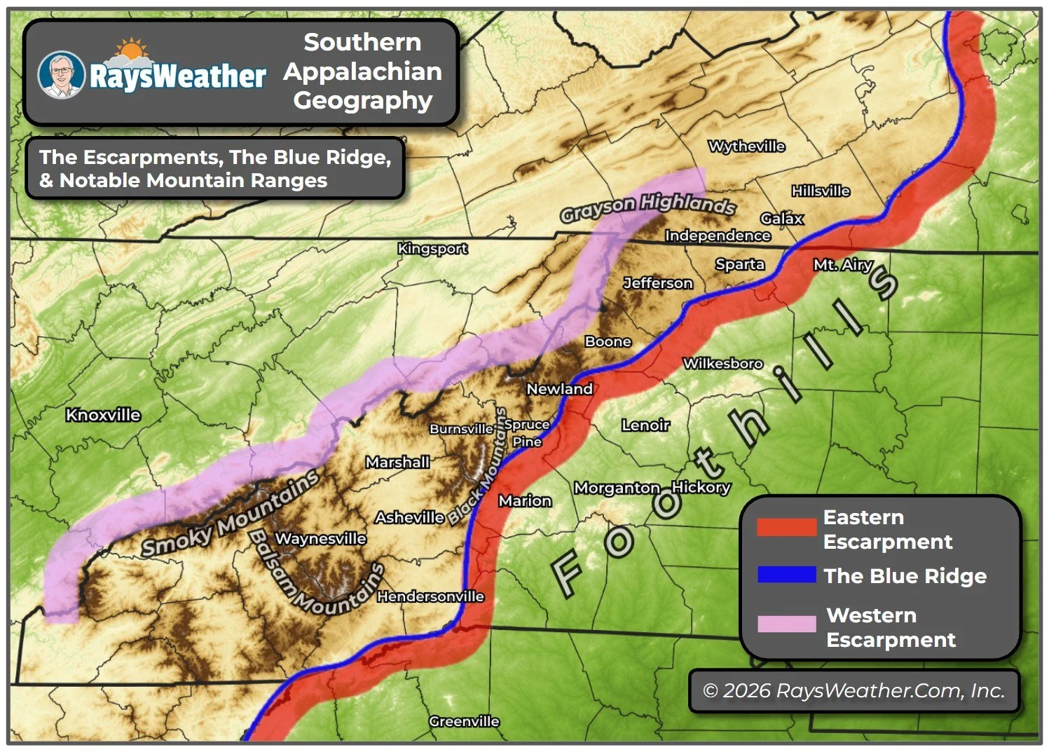
In this case, the Blue Ridge Escarpment marks the boundary between the higher Blue Ridge Mountains and the lower Piedmont. Rather than a single cliff, it is a broad transition zone where the land rises sharply from foothills into mountains.
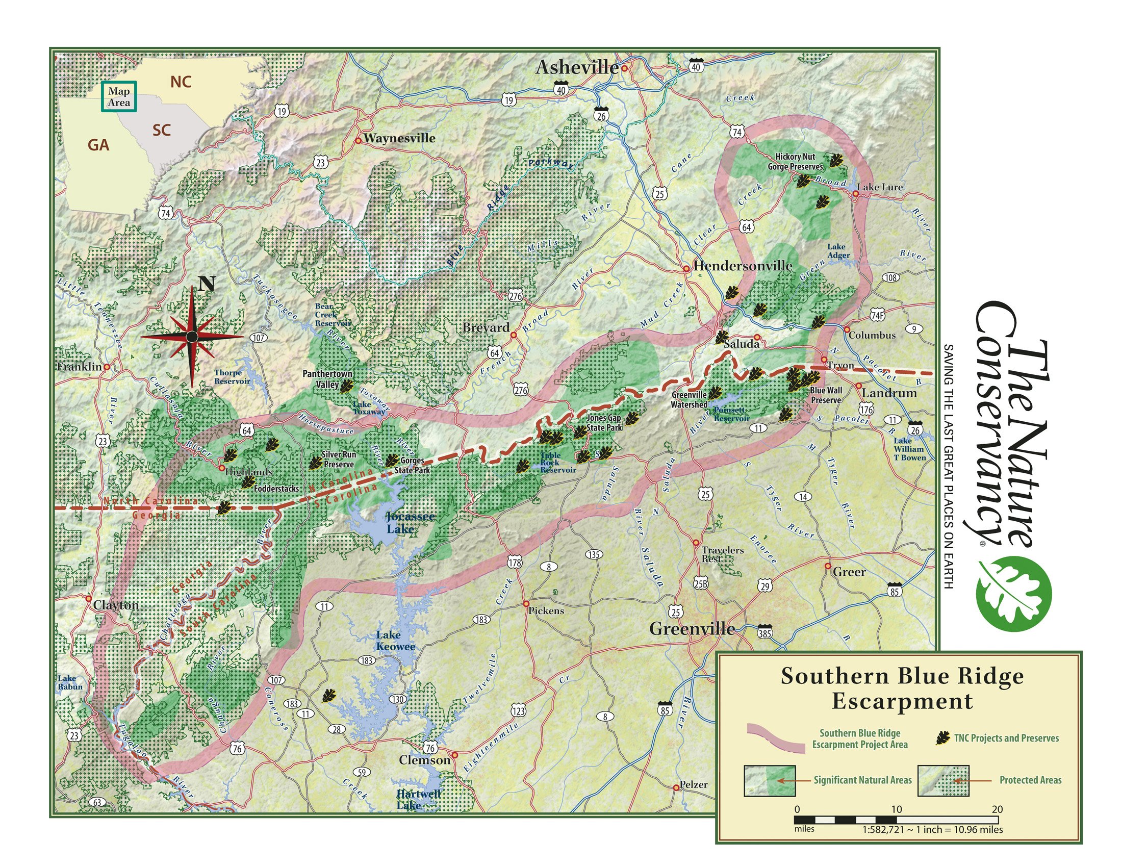
That rise can be dramatic. In many places, the elevation increases by 1,000 to 2,000 feet over a short distance. From a distance, particularly in upstate South Carolina, it appears as a continuous wall of mountains - a feature long known to the Cherokee as the “Blue Wall.”
The escarpment extends for roughly 250 miles along the eastern edge of the Appalachians, running through northeast Georgia, western North Carolina, and upstate South Carolina. It is this long, irregular boundary that creates the sudden transition experienced on roads like I-26 and U.S. 25.
The Blue Ridge escarpment is the result of a very long history. The Blue Ridge Mountains themselves are among the oldest in the world, formed between roughly 1.1 billion and 250 million years ago during a series of continental collisions. At that time, they were far higher than they are today.
-
Over hundreds of millions of years, erosion gradually reduced those heights. Water, wind, and gravity wore the landscape down unevenly, while rivers cut into the terrain and carried material away.
The escarpment likely emerged from this imbalance, where more resistant rock remained elevated while adjacent areas were lowered. Faulting may also have played a role, and geologists continue to study the relative importance of these processes.
That ongoing change is most visible in the movement of water. Streams and rivers flowing off the Blue Ridge descend quickly toward the Piedmont, cutting into the escarpment and forming steep gorges and narrow valleys. These processes continue today, especially during periods of heavy rainfall.
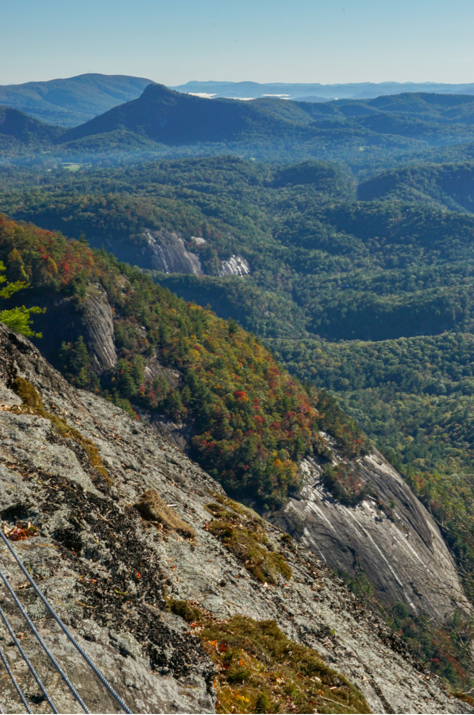
These same steep gradients help explain the abundance of waterfalls that are a defining feature of our region. Instead of winding gradually downhill, streams often drop abruptly over rock ledges. This pattern can be seen throughout the area, from Rainbow Falls in Gorges State Park to Linville Falls, Looking Glass Falls, and Crabtree Falls along the Blue Ridge Parkway.
-
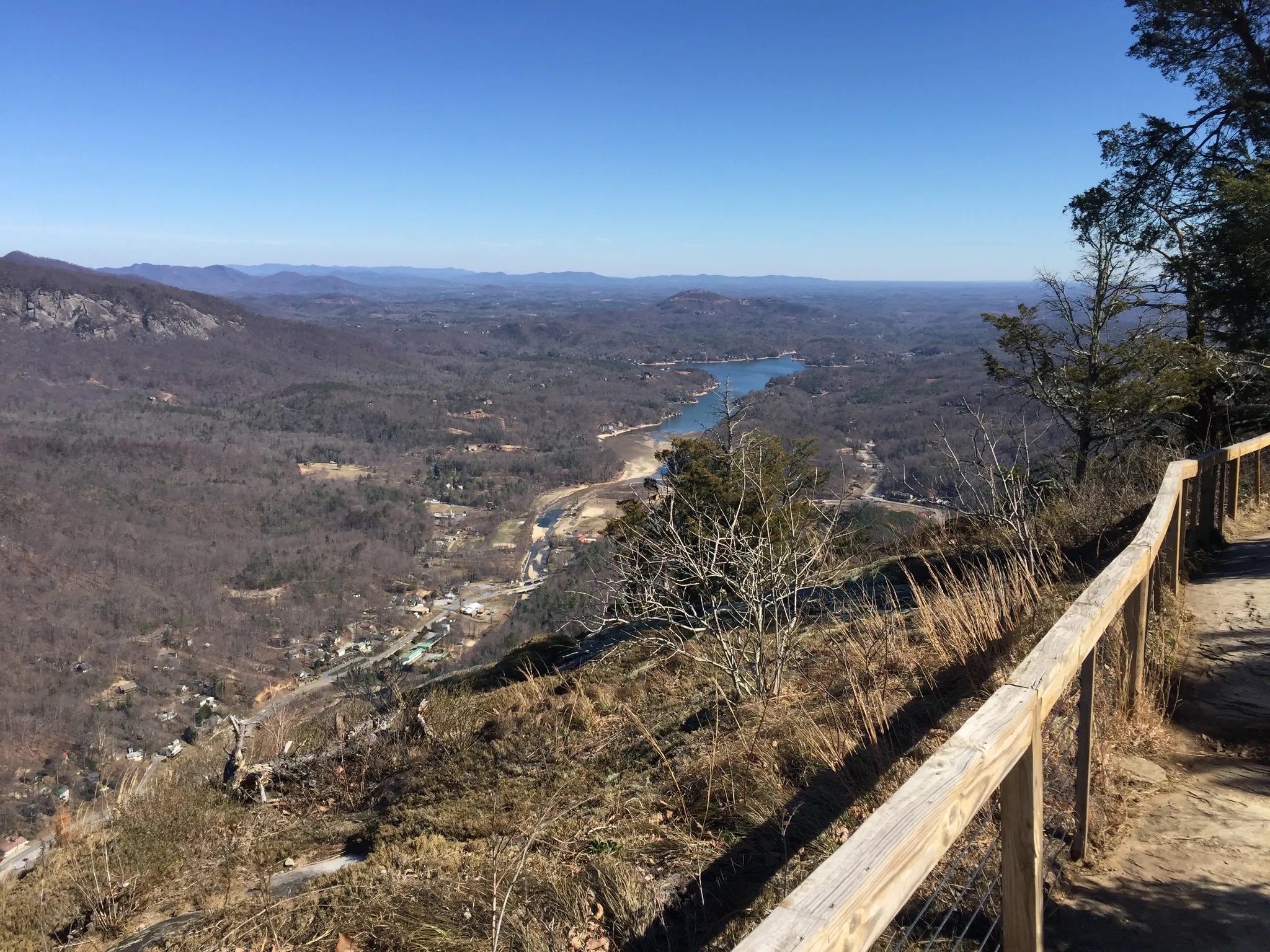
View From Exclamation Point and Skyline Trail to Hickory Nut Falls near Chimney rock towards Lake Lure
Water helps shape the escarpment, but the escarpment also shapes the water, beginning with the weather itself. As moist air moves inland from the Gulf of Mexico or the Atlantic, it encounters the rising terrain of the Blue Ridge. With no path forward, the air is forced upward. As it rises, it cools, and its moisture condenses into clouds and precipitation, in a process known as orographic lifting.
Because the escarpment is steep, this process is particularly effective here. Rainfall totals are often higher along the mountain slopes than in the surrounding foothills, contributing to some of the wettest conditions in the eastern United States. In extreme cases, the effect becomes more pronounced. During Hurricane Helene, moist air flowing from the south and southeast was forced upward along the escarpment, producing rainfall totals exceeding 30 inches in some locations.
The terrain also influences other weather patterns. During cold-air damming events, shallow cold air becomes trapped along the eastern slopes, producing extended periods of gray, damp conditions.
Together, these processes help explain both the frequency and intensity of rainfall in the region.
-
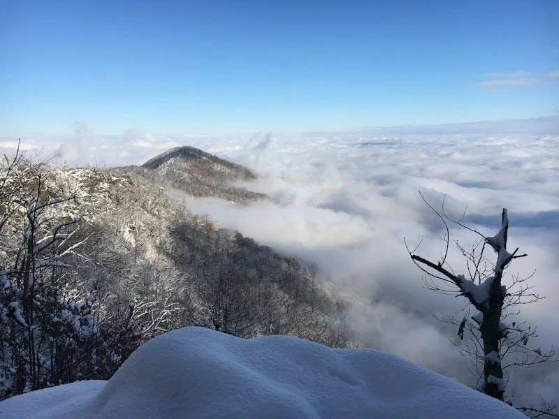
Fog over the Piedmont, viewed from western Polk County (Image: Evan Fisher)
Those wet conditions, combined with rapid changes in elevation, also help create a wide range of habitats. Within a relatively small area, the escarpment includes dry ridges, shaded slopes, and consistently damp coves. These variations produce distinct microclimates, each supporting different plant and animal communities.
As a result, the region supports a high level of biodiversity. Forest types shift over short distances, and moisture-loving species - such as ferns, mosses, and amphibians - thrive in protected areas. In places like the Jocassee Gorges, this diversity is especially pronounced. The escarpment’s structure, combined with its climate, makes it one of the more ecologically varied landscapes in the southern Appalachians.
Generations of residents responded to this landscape in different ways. For the Cherokee, the escarpment was the “Blue Wall,” a defining geographic feature of the region. For early settlers, it presented a practical challenge, with steep slopes limiting movement and shaping travel routes.
Over time, those routes were formalized into roads, including the steep grades near Saluda and along the escarpment’s edge.
Today, the escarpment is more often experienced as a destination. The Blue Ridge Parkway follows portions of the ridge line, offering access to overlooks, trails, and waterfalls. Millions of visitors travel these routes each year to experience the terrain and views. For our neighbors in Upstate South Carolina, a relatively short but very steep drive into Henderson County provides a dramatic shift in topography and temperature, making Flat Rock and the surrounding communities a haven for tourists.
-
Returning to one of those overlooks near Saluda or Caesars Head, the transition between mountain and Piedmont is very easy to recognize. The elevation change, the terrain, and the broad view all reflect the structure of the escarpment.
Ultimately, the Blue Ridge Escarpment is, at its most basic, a boundary. But it is also an active system that shapes weather, directs water, and influences the landscape over long periods of time. To live in this region is to live along that edge - where mountain and lowland meet, and where long-term geologic forces remain part of the present.
References:
Ray’s Weather: East vs West: An Explainer
Geologic Tour of the Blue Ridge Escarpment
The Wandering Appalachian; Blue Ridge Escarpment: The Wonders of The Blue Wall