The Great Divide in Flat Rock
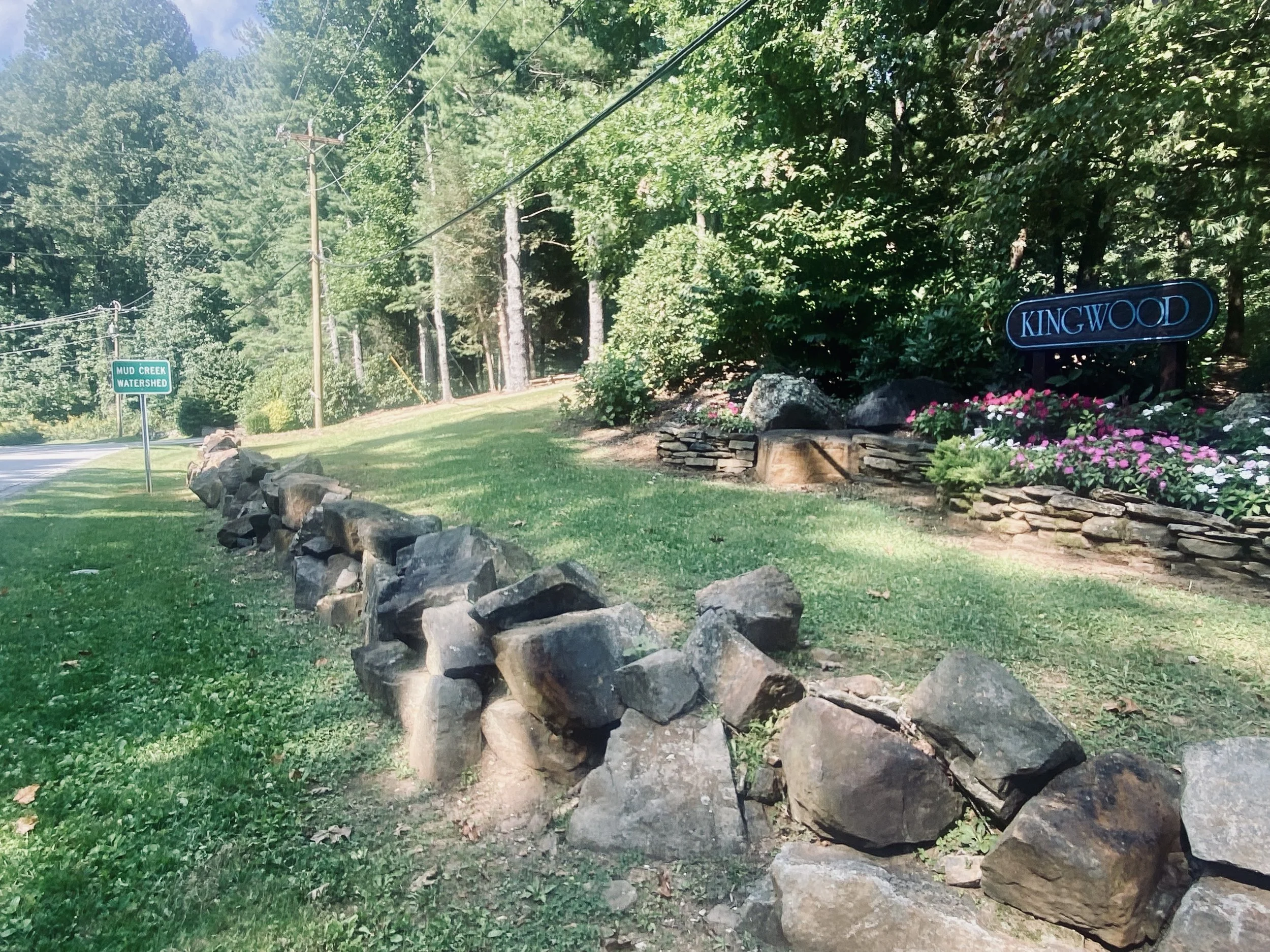
Mud Creek Watershed Sign at the Entrance to Kingwood
Roll into Flat Rock from the south on Greenville Highway and you’ll pass a blink-and-you-miss-it marker at the Kingwood entrance: “Mud Creek Watershed.” Not exceptionally interesting, and you might wonder why someone bothered to place the sign at that spot.
Until, that is, you realize what it really means.
That modest sign sits on the Eastern Continental Divide. At that point, within a few feet of asphalt, a raindrop in front of you is bound for the Gulf of Mexico, while its twin just behind you is headed to the Atlantic Ocean.
And more than simply deciding the path of water as it drains back to the sea, this invisible seam helped draw county lines, guided old roads and settlements, and still tilts our weather today.
It’s one of the biggest geographic thresholds in the East—and it runs straight through a section of Flat Rock and across the entire width of Henderson County.
-
The Mud Creek Watershed is part of the much larger French Broad River Basin. The Broad River Basin and the French Broad River Basin meet in Henderson County but carry water to opposite coasts. Rain that falls on the French Broad side (think Mills River and tributaries on the county’s northwest flank) runs to the French Broad River, joins the Holston at Knoxville to form the Tennessee River, then the Ohio, then the Mississippi, and finally reaches the Gulf of Mexico.
Major River Basins in North CArolina
By contrast, rain in the Broad River Basin(Green River, Hungry River, Rocky Broad/Lake Lure country) gathers into the Broad River, which meets the Saluda at Columbia to form the Congaree; the Congaree then joins the Wateree to become the Santee River, whose waters empty into the Atlantic along the Santee delta.
Especially intriguing about these two river basins is the fact that the boundary that separates these two drainage systems is part of the Eastern Continental Divide (ECD). In Henderson County, the ECD rides the Blue Ridge crest - Pinnacle Mountain to Bearwallow to Little Pisgah - so that a single ridgeline decides whether a raindrop is bound for the Gulf or the Atlantic.
The Divide Through Henderson
Section by Section
(click on maps to enlarge)
Path of the EAstern Continental Divide Through Henderson County. Based on maps generated by the National Oceanic and Atmospheric Administration (NOAA). Link to interactive map here.
Map 1
(1)
The Eastern Continental Divide enters Henderson County at the four-corners point where the North Carolina–South Carolina state line meets the Henderson–Transylvania county line. From that junction, it runs north along the county boundary, riding the ridgeline that separates South Prong Green River (Henderson) from Reasonover Creek (Transylvania) beside DuPont State Recreational Forest and the Green River Preserve, threading Green River Gap.
After the gap, the divide turns east and follows the crest of Pinnacle Mountain.
This Blue Ridge spine—“where the easterly and westerly waters divide,” as historian Jennie Giles puts it—sends the French Broad and Mills rivers westward while the Rocky Broad, Hungry, North Pacolet, and Green flow east.
When Transylvania County was created in 1861 from parts of Henderson and Jackson County, this clear watershed ridge offered a logical, easily mapped boundary that had historically shaped exploration, treaties, land grants, and early settlement patterns.
Impact on Weather
Because the divide is at or in proximity to the highest terrain, air is forced upwards regardless of wind direction. This process of orographic enhancement leads to higher precipitation than the surrounding areas. In winter, the divide is often much snowier due to orographic enhancement and cooler temperatures with elevation.
Flat Rock sits on the Blue Ridge escarpment right along the Eastern Continental Divide. The escarpment’s high, cool, very wet ridge tops (DuPont/Green River area, Pinnacle to Bearwallow) mean that Flat Rock sits on the fringe of the Southern Appalachian temperate rainforest. This zone is characterized by frequent cloud and fog, persistent upslope drizzle, and lush cove-and-hemlock hardwood forests.
Map 2
(2)
From Green River Gap (2,717 ft), the Eastern Continental Divide surges more than a thousand feet along the ridge to The Pinnacle (3,762 ft). The view looks north over the Crab Creek valley—once a historic Native path running below the crest—toward Jeter Mountain.
At the base of the climb, the divide meets the junction of Green River Road and Pinnacle Mountain Road, gateway to the Green River Preserve and site of Green River Camp.
At this point, the ECD and Pinnacle Mountain Road together define the southeastern boundary of DuPont State Recreational Forest.
Map 3
(3)
From The Pinnacle, the Eastern Continental Divide follows the ridge—roughly the line of Pinnacle Mountain Road—east toward Mount Olive (3,115 ft). Along this crest, the divide steps across Horsepen Mountain, Shaggy Mountain, and Ann Mountain, running roughly parallel to Crab Creek Road in the valley below.
Kanuga Conference Center lies due north across the Crab Creek valley. Off the ridge, Mt. Olivet Road and Cabin Creek Road drop south from Pinnacle Mountain Road toward Tuxedo.
Map 4
(4)
From Mount Olive (3,115 ft) the Eastern Continental Divide runs east-northeast along the crest, tracking just north of Pinnacle Mountain Road as it nears Greenville Highway (US-225).
For much of the stretch between Mt. Olivet Road and Sky Top Orchard, the divide rides the high rim above Crab Creek and functions as part of the southern boundary of the Village of Flat Rock. The ECD also splits the Kenmure neighborhood, with the main development to the north and Phases V & VI to the south near Pinnacle Peak Lane.
The divide passes just north of Sky Top Orchard, crosses McAlpine Mountain (2,946 ft), and then swoops down and across Greenville Highway at the entrances to the Kingwood and King Crest neighborhoods before climbing to King Mountain (2,625 ft).
Map 5
(5)
From Pinnacle Mountain, the Eastern Continental Divide drops to Greenville Highway (US-225) at the entrance to the Kingwood neighborhood, then climbs roughly 200 feet to the crest of King Mountain (2,625 ft).
Northbound travelers entering Flat Rock pass a modest “Mud Creek Watershed” sign at this crossing - an understated marker for the far more consequential line.
Here, the divide traverses the Village of Flat Rock proper, cutting through Kingwood, then rides the ridge along Kingcrest Drive to Mine Gap Road and on to Butt Mountain (2,674 ft). Much of Claremont Drive in the Claremont neighborhood runs about 200 feet below this crest, roughly parallel to the divide.
A small but distinct knob—unofficially “Flat Rock Together Mountain” (2,452 ft)—sits 0.33 miles due west of King Mountain.
(6)
From Butt Mountain, the Eastern Continental Divide rides the high ridge north, then swings east to cross Spartanburg Highway (US-176) just south of Roper Road.
Here, the first railroad into Flat Rock from the south—running between Butt Mountain and the Green River gorge to the east—crests the divide near the Roper Road intersection (≈2,150 ft).
Almost immediately, the divide turns north along Oak Grove Road, then strides across I-26 just south of Crest Road and north of the I-26/US-25 interchange.
Map 7
(7)
After crossing I-26, the Eastern Continental Divide rides Crest Road to Upward Road just east of Upward Elementary, then crosses Howard Gap Road and continues northeast along Upward Road to Marked Tree Vineyard.
On the NOAA GeoPlatform map used to make these maps, the divide bisects the Marked Tree tasting room and provides expansive views both east and west as you enjoy your favorite bottle of wine. In theory, a glass of wine tragically spilled on the west side ultimately travels to the Mississippi River and Gulf of Mexico, while a spill on the east side makes its way to the Atlantic Ocean.
This would be a good time to discuss the actual width of the Eastern Continental Divide. In reality, the width of the ECD varies significantly because it follows the complex topography of the Appalachian Mountains, rather than being a single, consistent feature. It can range from a very narrow ridgeline to multiple valleys and spurs, meaning it is not measured by a fixed width but rather by its complex path across the landscape, where drainage divides.
In addition, the line generated by the mapping programs is generally accurate, but probably not so accurate that one could reliably claim the ECD passes directly through any specific structure or landmark. Many divide/stream layers are made from 10–30 meter digital elevation grids and are then generalized (simplified) for web maps.
Still, the spilled wine makes a good story, and we will stand by our assumptions until proven wrong.
Map 8
(8)
From Marked Tree, the divide runs through Dana, follows Ridge Road to Sugarloaf Road, brushes Pilot Mountain (2,584 ft), then skirts just east of Lamb Mountain (2,632 ft) and Point Lookout Mountain to Point Lookout Vineyard (2,973 ft), where it jogs west toward Edneyville and US-64.
Map 9
(9)
From Point Lookout Vineyard, the Eastern Continental Divide jogs west and crosses U.S. 64 at Centipede Lane, beside the Blue Ridge Humane Society Shelter. From there, it winds north along the ridge, stepping over Whiteside Mountain, Chickasaw Knob (2,653 ft), Barnwell Mountain, Raven Rock (2,753 ft), Grant Mountain, and Little Bearwallow Mountain, before topping out on Bearwallow Mountain (4,234 ft).
The divide then bends east around Gerton, threads Hickory Nut Gap and the Florence Preserve, and finally exits Henderson County at Little Pisgah Mountain (4,410 ft) into Buncombe County.
Conclusion
The Eastern Continental Divide is more than a cartographic curiosity. It’s the quiet backbone that has shaped how people have lived, traveled, drawn lines, and told stories here. More than simply deciding whether a single raindrop runs to the Gulf of Mexico or the Atlantic, the Eastern Continental Divide that runs through Henderson County and Flat Rock also guided treaties, county boundaries, roadbeds, and early settlement patterns.
What’s unusual in Flat Rock and our neighboring communities is how intimately that line threads everyday life. The divide doesn’t stay on distant peaks but bisects the village and the county while slipping past front porches, schools, vineyards, and neighborhood streets.
Few communities can point to a continental divide running through their midst; fewer still can trace it as clearly on the ground. That rare geography gives Flat Rock a heightened sense of place. A place where “easterly and westerly waters” part ways.
Ultimately, the Eastern Continental Divide is one more reason our small village is, and has always been, an exceptional place.